In 2021, NatureNS student Matt Campbell pulled together a list of Nova Scotian trails where amateur and expert naturalists alike can find some prime examples of Nova Scotia’s diverse natural history. Here are some of his picks.
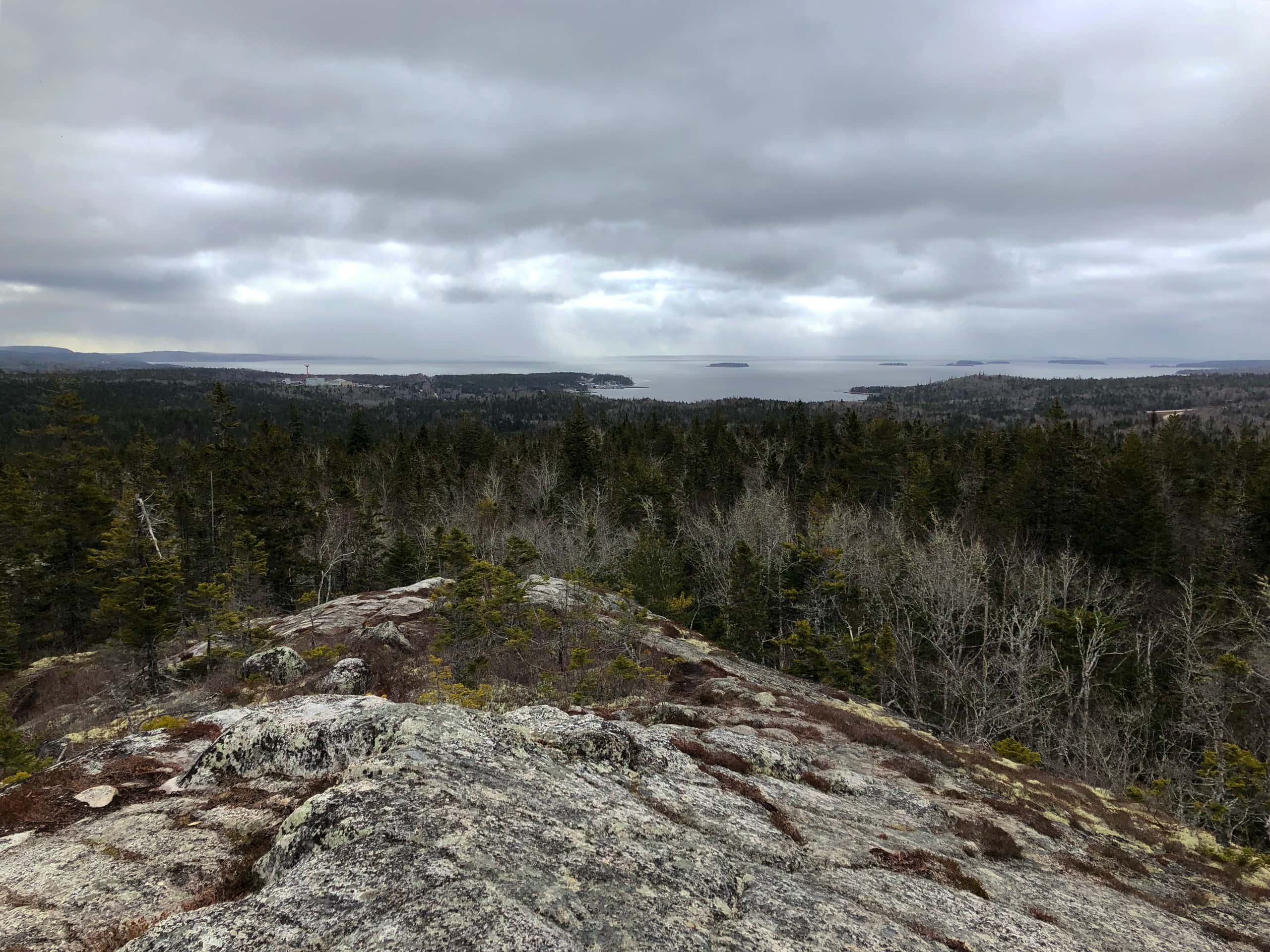
Castle Rock, East River, Lunenburg County

Castle Rock Trail leads to a granite outcrop with panoramic views of Mahone Bay and wilderness along the South Shore of Nova Scotia. Accessibility is quite good due to the majority of this trail being the Chester Connector Trail, a rails-to-trails section of the Rum Runners Trail extending to Halifax. The trail is rated as moderate, with a total elevation gain of 118 metres and a distance of 8.2 km. It is very well marked, with significant up-to-date signage at the location where Castle Rock Trail splits off from the main trail near Labrador Lake. There are two well-marked routes to choose from – red, the easiest, is an ATV trail that passes through a former Christmas tree farm. The topography and change in plant life make this clear. A blue marker appears near the top, which is a slightly more challenging route that splits from the ATV track to get to the outcrop. Yellow is the most challenging route, a narrow path that is heavily rooted and rocky in some places, as well as much steeper. This route also offers a lower granite outcrop with significant lichen growth before continuing on to Castle Rock itself. A bike rack where the trail begins from the main Chester Connector Trail suggests that access to Castle Rock is much more readily available. Plant/Fungus Species observed include: hobblebush, gold dust lichen, Usnea longissima, winterberry holly, blue toadflax, blue clubmoss, and pine barren goldenheather. Animal Species observed include: ruffed grouse, northern redbelly snake, American red squirrel, American black ducks, and mallards. Directions at HalifaxTrails.
Jodrey Loop, Blomidon Provincial Park, Kings County
Jodrey Loop is part of the trail network within Blomidon Provincial Park, listed as moderate and featuring expansive views of the Minas Basin on the coastal stretch of the loop. It is 8.2 km and has an elevation gain of 184 metres, with wooden viewing platforms along the trail overlooking the cliff and Basin below. Trails are well maintained with the aforementioned viewing platforms, with some short boardwalks to improve access and minimize erosion. The trail itself is well marked, and is rated as moderate for hiking. As it is a provincial park, access may be limited in winter months due to the park gates being closed, and thus walking up the steep road may be necessary to access the trail. Plant/Fungus Species observed include: broad-leaf goldenrod, hobblebush, red trillium, balsam fir, common selfheal, Christmas fern, conifer mazegill, New England sedge, and bluebead lily. Animal/Insect Species observed include: Snowshoe hare, wood frog, painted turtle, seven-spotted lady beetle, tricoloured bumblebee, common garter snake, and American red squirrels. Directions at AllTrails.
High Head Trail, Prospect, Halifax County

Part of the Dr. Bill Freedman Nature Reserve at the head of Shad Bay, High Head Trail offers an excellent opportunity to hike a scenic coastal trail teeming with wildlife and diverse plant species. The trail starts in a heavily wooded area that has some signage at the trailhead and some sections that are maintained, although after heavy rain the trail becomes challenging due to large puddles and muddy sections. Improvements have been made including wooden boardwalks in more sensitive or swampy areas, though there are wet sections further along the trail. After a brief 5-minute walk through the forest, hikers find themselves on a cliff facing the bay, with the trail going off to their left. From here, an expansive view of the coastal barrens that make up a large part of the Reserve can be seen. Following along the braided trail that meanders near the shore, evidence of coastal erosion is apparent in areas that are not the granite outcrops that make up the majority of this coastline. Tidal pools The trail ends up near Prospect Village, and thus can be either point-to-point or an out-and-back hike. Plant/Fungus Species observed include: Whorled wood aster, American cranberry, bog cranberry, Canadian bunchberry, black crowberry, northern bayberry, bog aster, Labrador tea, purple pitcher plant, and beach-head iris. Animal/Insect Species observed include: Bald eagle, cormorants, Lapland longspur, European green crab, rock crab, Jonah crab, tricoloured bumblebee, great black-backed gull, smooth greensnake, American carrion beetle, periwinkles, porcupine, and white tailed deer. Directions at HalifaxTrails.
Salt Marsh Trail, Cole Harbour/Lawrencetown, Halifax County

Beginning in Cole Harbour and ending at Lawrencetown Beach Provincial Park, the Salt Marsh trail is a lengthy former railway that has been converted to a moderately trafficked cycling/walking trail that offers stunning views of the salt marshes it crosses. It is also a part of the Trans-Canada Trail. At 19.5 km in length including the return from Lawrencetown Beach, it is rated at moderate due to the distance; a shorter version is the first 4-6 km, which allows users to still see salt marsh plants and wildlife, but does not go through the forested areas and marshes further along. Walking is easy due to crushed gravel trails that are well maintained with bridges passing over channels in the marsh, and dedicated signage showing distance, trail maps, and wildlife profiles all along the route. Cycling the full 19.5 km takes about 2.5 hours, with a brief stop at Lawrencetown Beach itself. Ecologically, there is a diverse and abundant group of birds, as well as various plants all along the trail, and therefore this trail would be phenomenal for birders. Plant/Fungus Species observed include: Bluebead lily, red maple, red oak, northern seaside goldenrod, rugosa rose, beach sedge, tufted vetch, seaside pea, and balsam fir. Animal/Insect Species observed include: Atlantic blue crab, herring gull, hooded merganser, black-bellied plover, American wigeon, bald eagle, great blue heron, double-crested cormorant , American red squirrel, European starling, blackcapped chickadee, Eastern kingbird, American black duck, mallard, Nelson’s sparrow, snow bunting, least sandpiper, common eider, greater yellowlegs, white tailed deer* and Eastern chipmunk. For reference, the first kilometre of the trail passes through a forested area, and many flycatchers, finches, and other small songbirds can be found here. Directions at HalifaxTrails.
Admiral Lake Loop, Musquodoboit Harbour, Halifax County

Another trail that has beginnings along a rails-to-trails route, Admiral Lake Loop is a challenging 9.3 km route that climbs to a look-off known as Skull Rock, where the Musquodoboit Valley can be seen. One of the more challenging trails on this list, the route is rated as moderate but steep climbs and rough trails mean that Admiral Lake Loop is for a more experienced hiker. Primarily in heavily wooded terrain, roots and large rocks are some of the obstacles hikers may face. Massive granite boulders create short caves and tunnels against the rock face, allowing for shelter from the heat and persistent insects during summer hiking. Winter hiking on Admiral Lake Loop would not be ideal or safe, given the condition of the trail itself. Plant/Fungus Species observed include: Red maple, starflower, flat-top white aster, pickerelweed, sheep laurel, and trailing arbutus. Animal/Insect Species observed include: American red squirrel, black-capped chickadee, double-crested cormorant eastern chipmunk, American toad, and pickerel frog. Directions at Musquodoboit Trailways Association.
Gaff Point & Hirtles Beach Loop, Kingsburg, Lunenburg County

Gaff point is geologically stunning, with features such as folded sedimentary rock on display along the loop as well as tall cliffs facing the beach itself. Starting at a well-established parking lot by Hirtles Beach, hikers walk towards Gaff Point for some distance before arriving at the base of the trail. The entire loop is 6.6 km, but small offshoot trails on the peninsula can exited this somewhat, including a hidden trail that leads to “Secret Beach”, a small sandy cove tucked away on the back side of the peninsula accessible by rappelling down a steep bank from the woods above. The trail is fairly well maintained, with various types of trail maintenance evident including rudimentary boardwalks, log paths, and some signage to guide hikers. The most difficult part of this hike is the long walk to and from the peninsula on the sandy Hirtles Beach. Plant/Fungus Species observed include: Seaside pea, cinnamon fern, common juniper, bog aster, American cranberry, creeping snowberry, and low bush blueberry. Animal/Insect Species observed include: Yellow-rumped warbler, common eider, American red squirrel, northern parula, Swainson’s thrush, silver-spotted anemone, northern gannet, and white-winged crossbill. Directions at HalifaxTrails.
Pollets Cove Trail, Aspy Fault Wilderness Area, Inverness County

North of Red River in Cape Breton, Pollets Cove is a remote wilderness hike that follows along the island’s western shore with a round-trip distance of 13.2 km. The trail begins at the end of a rough dirt road and immediately climbs into the rolling hills along the coast. Near the trailhead, there is a small cabin that lacks a door, and can likely be used as shelter in inclement weather. The majority of the trail is heavily wooded, narrow, and features steep climbs as well as notably rooted sections, but overall is in good condition for a more experienced hiker. As it follows along a very steep cliff, caution should be taken to not get too close to the edge, as erosion of the upper sections of the cliff face is evident. Some sections are open, including a meadow area about halfway with tall grasses that the trail cuts through while descending into a small valley with a creek and the bottom that needs to be crossed to continue on. The trail then ascends back into the forest before eventually opening up to reveal Pollets Cove itself. This is a large open field area where horses can be found roaming, and camping is possible if hikers decide to stay overnight and hike back the next day. Plant/Fungus Species observed include: Northern bayberry, white-fruited red baneberry, black chokeberry, spotted Joe-Pye weed, nodding trillium, and herb Robert. Animal/Insect Species observed include: Domestic horses, pilot whales, grey seals, cedar waxwing, maritime garter snake, bobcat, great horned owl, great spangled fritillary, Virginian tiger moth, and moose. Directions at AllTrails.
Ward Falls Trail, Diligent River, Cumberland County

Maybe a more difficult-to find trail, Ward Falls is also a stunning and geologically significant trail. Following along the river, valley walls with dense tree cover rise up on either side. The trail is a 6.6 km out-andback moderate hike, with bridges crossing over the river several times. The trail is rough in some places, with floodplains evident and some bridges in disrepair, although it appears that work was being done in 2020 to improve, repair, or replace these crossings. Insect life is abundant along the trail, notably horseflies, deer-flies, blackflies and mosquitoes are a constant from the trailhead through to the waterfall itself, although they seem to be less abundant at the waterfall. Looking closely in the river and plunge pool, hikers can find plenty of brook trout. Plant/Fungus Species observed include: Red sand spurrey, red baneberry, shinleaf, ochre jelly club, red-banded webcap, chaga, false chanterelle, and bluebead lily. Animal/Insect Species observed include: Horseflies, blackflies, deer-flies, mosquitoes, white-tail deer, western honey bee, barred owl, brook trout, and American red squirrel. Directions at AllTrails.
Kentville Bird Sanctuary, Kentville, Kings County
Kentville Bird Sanctuary is an easy-rated 3.9 km loop located between the towns of Kentville and Coldbrook, and is part of a larger network of trails in the area. Taking some of these smaller trails can extend the length of the hike significantly if the user decided they wanted to spend more time in the area to see the abundant wildlife in the Sanctuary and beyond. The loop is an offshoot of the Cornwallis River Greenway, The trail is not well marked so it can be easy to get off course, but the trail network eventually reconnects with there main Greenway. There are evident floodplains in some sections, but overall the trail is smooth single or double-track that is good for cycling, walking, hiking, or running. As its name suggests, there is a significant bird presence along the trail, particularly near the sanctuary itself. Plant/Fungus Species observed include: Northern red maple, northern blue flag, stinging nettle, sheep laurel, tree lungwort, and bluebead lily. Animal/Insect Species observed include: Blue jay, eastern chipmunk, bald eagle, American red squirrel, maritime garter snake, white-tailed deer, raccoon, black and white warbler, white-breasted nuthatch, Virginia rail, hairy woodpecker, pileated woodpecker, blue-headed vireo, and black-capped chickadee. Directions at AllTrails.
Economy Falls Trail, Economy, Colchester County

Economy Falls Trail is a relatively short hike at only 1.4 km return, but the rough River Phillip Road leading to it may stop would-be hikers from driving all the way to the trailhead unless they had a 4WD vehicle, and thus tripling the length of the hike. A fork in the road 2.6 km from the trailhead offers enough space for parking and while the road may be unsuitable for cars due to severely washed-out sections, it is a fairly easy hike through a wooded area. Upon reaching the trailhead, the path is smooth, wide, and obstruction-free. After 0.6 km, a steep built-in stairway descends to the base of the waterfall, with an excellent view of the geological features including a deep gouged-in waterfall. The remoteness and difficulty accessing the trail ensures a quiet and uninterrupted view of the waterfall and its surroundings. Plant/Fungus Species observed include: Rock polypody, common hemp-nettle, red trillium, white baneberry, dead man’s fingers, Canadian bunchberry, and American water-pennywort. Animal/Insect Species observed include: Mink frog, wood frog, American lappet
moth, and American red squirrel. Directions at NS Waterfalls.
For more trails, guide book recommendations, and how to join a hiking club, check out the resources at Hike Nova Scotia. Or join your local natural history society for more on the unique wildlife found in all of these great recreational spaces!