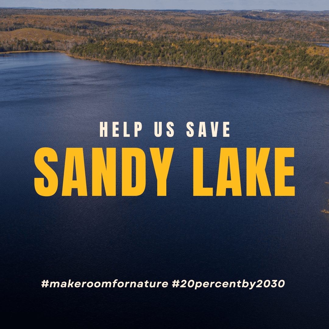
Undeveloped Shorelines and Rare Old Forests in Bedford NS Threatened by Rushed Housing Order
The Sandy Lake-Sackville River Regional Park is a conceptual protected area nestled inside urban Bedford that supports several significant freshwater bodies and rare old forest ecosystems. This rare wild refuge inside Atlantic Canada’s largest city spans much of northern Bedford between the 102 and Hammonds Plains Rd into North Kingswood, near Lucasville, and supports some of the last mature forests in the city core. The main lake, “Big Sandy,” surrounding wetlands, and nearby “Marsh Lake” are major components of the Sackville River Watershed and provide filtration and runoff mitigation services for thousands of nearby residents.
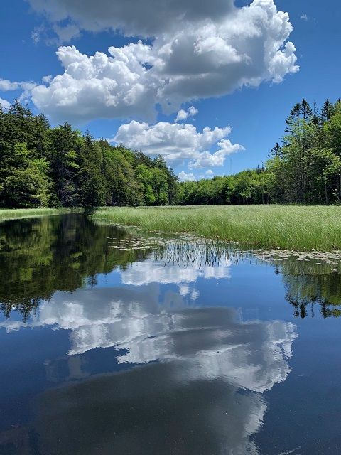
The lakes are bordered by rich drumlins that support mixed, multi-aged Wabanaki-Acadian forest with significant old-growth stands and striking “pit and mound” topography. The mainland moose, eastern wood pewee, wood turtle, and other provincially and nationally rare species have been spotted here. The area is especially unique for its three different kinds of northern lakes: one a shallow, nutrient-rich lake bordered by marsh vegetation; one a deep “blue lake”; and one a boreal forest lake, surrounded by peatmoss and spruce trees.
Though only some of the area is now formally protected as municipal park land, the greater region was identified through several municipal planning processes long ago for its important ecological and recreational benefits and prioritized for future protection, such that the public have often (and understandably) assumed the area to already be legally protected:
Paul Dean, Wildlife Biologist with the Canadian Wildlife Service, released a report in 1971 titled “Natural Environment Survey: A Description of the Intrinsic Values in the Natural Environment Around Greater Halifax-Dartmouth,” which identified seven sites in the greater Halifax area that held regional significance for recreation and environmental protection (at the time, Sandy Lake was part of Halifax proper, not Bedford). The following “Recreation Work Growth Report” estimated the amount of land required to create seven regional parks in the areas identified in the Dean report . A draft regional development plan was released in 1973 that included this proposed regional parks system.
On the basis of these studies and the regional development plan, seven ‘Regional Parks’ were designated in 1975 (without formal protection) to “protect areas of unique natural significance against adverse effects and to reserve sufficient open space for recreational purposes”. They included the Shubenacadie Canal, Hemlock Ravine, Long Lake, McNabs Island, Admirals Cove, the Cole Harbour Salt Marshes, and Sandy Lake. In 1976, the Metropolitan Area Planning Committee (MAPC) approved the establishment of a Parks Advisory Group to carry out planning studies on these regional parks and set actions in motion that would give them formal protection. They produced a full report in 1979 describing each park, including proposed development concepts, projected development and acquisition costs, boundary recommendations, and ownership details and that recommended the immediate acquisition of key privately held land parcels in the proposed park boundaries, as such lands could be lost to development before they might be meaningfully protected. In the intervening years, all six of the other regional park locations were formally protected through land purchases and formal designation as municipal or provincial protected areas, but the Sandy Lake Regional Park proposal ran into some trouble.

A local resident offered to give 500 acres at the west end of Sandy Lake to the Municipality of Halifax County, for the purpose of achieving the Sandy Lake Regional Park goal, on the condition that the park be named after her deceased husband. The county warden at the time declined the offer and it was rumoured that the city was looking for opportunities to develop tax revenue in the area, rather than make progress on the park plan. Instead, the city allowed Twin Cities Dairy (the ‘Dairy’, renamed Farmers Dairy and currently Agropur Cooperative Dairy) to purchase land in the same area, which resulted in nutrient pollution entering the normally oligotrophic-leaning Sandy Lake and ultimately resulted in the formation of the the Sandy Lake Ratepayers Association. That group hired consultants and worked with the Dairy to build holding ponds for effluent instead. The Dairy (now Agropur) has remained a good corporate citizen for the area and for Sandy Lake. It was the second body to join the more recently created Sandy Lake-Sackville River Regional Park Coalition and works with the Coalition today to mitigate ongoing concerns around the dairy’s operation close to the lake.
At the time, though, the impact of the dairy’s new presence on land that had previously offered protection to local water quality was such a shock to the community and the Sandy Lake Ratepayers Association that they began to work with the Town of Bedford (by then the Sandy Lake area was part of Bedford) to ensure better protection for the area in the future. Local residents and the original proponents for a connected park system didn’t want more industrial or other development that might prevent the conceptual park from being achieved.

The province changed the Planning Act in 1983, withdrawing the “Regional Park” designation category for all 7 park areas, and at about that time the pro-development members of the Bedford Town Council were able to pass a change in zoning at Sandy Lake that changed the park designation to development reserve – affecting about half of the lands that had been identified by the 1971 and subsequent assessments. These areas were essential to the survival of the Sandy Lake Regional Park ecological unity. In an effort to mitigate that decision, Mayor Francene Cosman and supportive councilors worked with the Sandy Lake Ratepayers Association to draft a municipal by-law that prevented new development in the Sandy Lake watershed and area unless the proponent owned 5 acres on a publicly serviced road and the road was public before October 9, 1991. This regulation still protects parts of Sandy Lake today, though developers have begun to assemble parcels in recent years to bypass this protection.
The Town of Bedford purchased additional parts of the shoreline of Sandy Lake for the proposed park and, in 1992, the Dairy gave 6 acres of shoreline to the Town of Bedford for the park with the requirement that there be no vehicular traffic permitted on that land. In 1996, the province gave 1,000 acres of its lands at Jack Lake to the city to designate as parkland, thanks in large part to the efforts of the Sackville Rivers Association. In 2004, the Bedford Lions Club donated $500,000 to finally establish the accessible swimming beach originally proposed in the regional park plan, ultimately resulting in the designation of a portion of lake’s east side as municipal park land. For a time, it looked like Sandy Lake was on track to reach its full potential as a protected Regional Park, even as the now-recognized-as urban sprawl planning disasters at Kingswood North and South grew up around it.

Under the 2006 Regional Municipal Planning Strategy, however, HRM carried that 1983 Bedford Town Council zoning change at Sandy Lake Regional Park into the Regional Plan as an urban settlement area. In the same year, thanks again to the Sackville Rivers Association’s work, the HRM-owned Jack Lake lands together with the Lions Club Beach on Sandy Lake were identified as part of the new proposed Jack Lake Regional Park. This park is also still to be formally designated. It seemed like city staff and councilors were unaware of the years of work that had gone into the park’s planning before their tenure, or that the term “Sandy Lake Regional Park” continued to be included in current planning documents and briefs even as zoning changed.
In 2013, when developer-owner Armoyan clearcut 300 acres of forest in the 500 acre contentious area west of Sandy Lake (remember those lands a local wanted to donate?), citizens formed the Sandy Lake Conservation Association and worked to save parts of the western end of the park from more clearcutting, re-engaged city councilors and staff, and started a petition to get the park actually designated as municipal park land. City planners confirmed that the city-owned lands were indeed considered park lands, but only the beach area was actually managed by the parks department.
Though Armoyan sold its remaining lands west of Sandy Lake to Clayton Developments in 2015, things were starting to look up when the city also purchased 160 uncut acres from Armoyan and added them to the park. A staff report recommended several additional parcels be reserved for parkland, despite the wording of the new Regional Municipal Planning Strategy, and Sandy Lake was included in the draft Halifax Green Network Plan, finalized in 2018. In 2021, Ducks Unlimited Canada recognized Marsh Lake as one of the province’s Treasured Wetlands and continue to direct visitors to this unique site. Shortly after, the city commissioned a new study on the Sandy Lake watershed to better understand the ecological values other organizations and citizen scientists had been reporting for years. This report confirmed the presence of several Species At Risk and underscored the importance of protecting the area.
In 2022, though, Sandy Lake was identified through the province’s new Task Force on Housing as a location where Nova Scotia would fast-track desperately needed housing development. This sweeping decision side-lined progress made with city staff and councilors who were trying to deliver on promises to protect Sandy Lake. The province hopes that new contracts with developers on the west side of the lake will result in 6,000 units being built.
Citizens have worked to protect Sandy Lake since before the 1970s. We and other members of the Sandy Lake-Sackville River Regional Park Coalition think it’s time that the Nova Scotia government and Halifax Regional Municipality finally protect this rare gem, once and for all.
Political decisions made without a real awareness (or care) for the ecological value of Sandy Lake are what led us to where we are today. It will take a political decision now to rectify past mistakes.
Write to the Premier, your MLA, and your city councilor, and demand action for Sandy Lake:
Request that the Province’s Task Force on Housing remove Sandy Lake from the Special Planning Area list.
Ask the Province to expand the park to its full 2,800 acres by working with neighbouring landowners to prioritize nature conservation over rushed, unsustainable development.